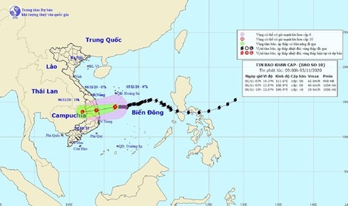
 The movement of Storm Goni in the East Sea (Photo: National Centre for Hydro-Meteorological Forecasting) The movement of Storm Goni in the East Sea (Photo: National Centre for Hydro-Meteorological Forecasting) |
At 1am on Thursday, the storm’s eye was about 290km to the south of Hoang Sa (Paracel) Archipelago, sustaining winds of up to 60-75km per hour. It will move west-southwest at about 10km per hour and subside to a tropical depression with the strongest winds of some 40-60km per hour. Between 1am and 1pm on Friday, the depression is predicted to move mainly west-southwest at some 10km per hour, make landfall from Quang Ngai to Khanh Hoa, and continue to weaken to a low-pressure area.
The south-central provinces of Quang Nam, Quang Ngai, and Binh Dinh are likely to record 250-350mm downpours. Meanwhile, rainfall of 100-200mm is projected for the surrounding localities of Thua Thien-Hue, Da Nang, Kon Tum, Gia Lai, and Phu Yen. The north-central provinces from Ha Tinh to Quang Tri will experience 100-200mm rainfall.