(VOVworld) – The Chinese public has been closely following every development of Vietnam’s public disclosure of an ancient map proving its sovereignty over Truong Sa and Hoang Sa archipelagoes. Chinese news agencies have covered Vietnam’s revelation of a Chinese map showing that the Hoang Sa (Paracel) and Truong Sa (Spratly) Archipelagos do not belong to China. China’s Ifeng station reported on the ceremony that was held to hand over the map to the National Museum of Vietnamese History by Dr. Mai Ngoc Hong. Ifeng quoted Dr. Hong on the historical importance of the map, which was made by China and printed by the Shanghai Publishing House in 1904. The Chinese Stockstar and Sina’s military website, http://club.mil.news.sina.com.cn, described the size and origin of the map and said that, according to the document, China stretches as far as Hainan island. This means Hoang Sa and Truong Sa are outside China’s territory. The article posted on the website highlighted the research work and remarks by Dr. Mai Hong and historian Duong Trung Quoc about the legality of the map, using Western methods which show modern latitude and longitude coordinates clearly. In particular, Stockstar called the two archipelagos by their Vietnamese names, Hoang Sa and Truong Sa, which are often referred to in Chinese names by the Chinese government.
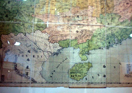
In 1904, the Shanghai Publishing House printed this map and distributed it to all provinces of the Qing Dynasty, the last imperial dynasty of China ruling from 1644 to 1912. (Photo: internet)
|
Less than 2 days after this ancient map was posted, video clips on this topic posted on the web by Ifeng and Sina attracted half a million viewers. The document is at the center of an increasing tense territorial dispute between China and its neighbors, including the Philippines, Vietnam, Malaysia, Brunei and Japan.
While many Chinese have always believed that the Hoang Sa (Paracel) and Truong Sa (Spratly) archipelagos belong to China, some Chinese media agencies have reported conflicting viewpoints on the issue, including the 1904 Qing dynasty map and Chinese scholar Li Linghua’s criticism of China's U-shape border in the East Sea saying it has no legal foundation.
Analysts agreed that Chinese media covering the discovery of the Qing dynasty’s map without Hoang Sa and Truong Sa will help change the viewpoints of Chinese population deluded themselves with China’s U-shape border in the East Sea with no legal foundations.