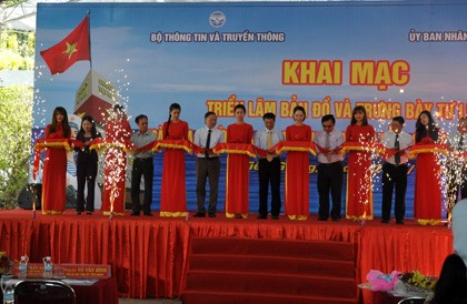
(VOVworld)- The Ministry of Information and Communications and Tien Giang’s provincial People’s Committee put on an exhibition themed “Vietnam’s Hoang Sa, Truong Sa – Historical and Legal Evidence” in My Tho city on Friday.
 |
| The opening ceremony of the exhibition (Photo: baoapbac.vn) |
Deputy Minister of Information and Communications Pham Hong Hai said the display of maps and documents was important as it helps raise the people’s awareness and sense of unity and responsibility about protecting Vietnam’s sovereignty over the Hoang Sa (Paracel) and Truong Sa (Spratly) archipelagos. Dr. Nguyen Quang Ngoc, President of the Vietnam Association of Historical Sciences, said: "The struggle for safeguarding national sovereignty and territorial integrity is the common responsibility and task of all people. Young people are most responsible because they are directly involved in undertaking this task. The exhibition provides good opportunities for young people to become more confident and willing to fight for national sovereignty”.
On display are more than 200 items including maps, photos, documents and other publications dating from the 17th to the 20th centuries.
In particular, there is the World Atlas of Geography compiled by Belgian geographer Philippe Vandermaelen (1795 – 1869) indicating that Hoang Sa and Truong Sa belong to Vietnam.