 |
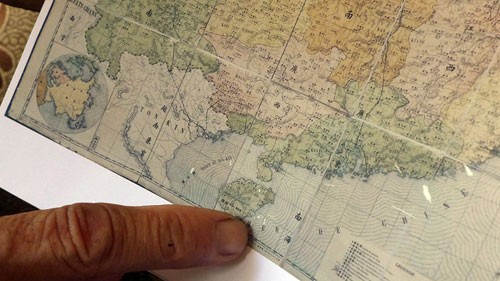
| The map indicates that Hainan Island is the end of China to the South |
(VOVworld)-The National Museum of History has received an ancient map collected by a Vietnamese scholar rejecting China’s territorial claim of Hoang Sa and Truong Sa Archipelagoes. Dr Mai Hong, a former director of archives at the Han Nom Institute will present the ancient map to the museum on Wednesday. Hong said the map was drawn by Chinese intellectuals under the Qing regime from the 18th to 19th century“This is a document generated by the Qing dynasty and it is an undeniable proof. I offer the map to the museum so that both countries and the world community would gain a correct understanding about the historic fact”
The map depicts Hainan Island as the southernmost territory of China, which means Hoang Sa and Truong Sa Archipelagoes are not part of China.
According to Pham Hoang Quan, a local researcher on Han-Chinese and Demotic Scripts, the map, measuring 115cm long and 140cm wide, was printed on separate sheets and belonged to a group of large-scale maps.
The map’s accuracy in terms of longitude and latitude is nearly on a par with modern maps. This map was made by experts at the Observatory of the Qing Dynasty, so it can be considered official, he said.