(VOVworld)- Historic images of Hanoi, Haiphong, Hue, Nha Trang and Saigon in the late 19th century were depicted in a valuable collection of photographs by Governor-general of Indochina Armand Rousseau. More than 200 photos taken by Rousseau are on display at the National Library to mark the 40th anniversary of Vietnam-France diplomatic ties. Armand Rousseau was appointed Indochina Governor-general in February 1895, but he died suddenly on December 10, 1896 and left behind hundreds of photographs that he took in 1895-1896. The pictures are considered precious historical documents on Vietnam from the late 19th century.

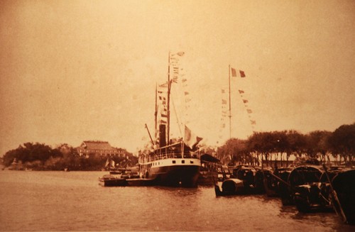
Saigon became a city in 1874. When Rousseau arrived in 1895, it was a noisy and bustling city. The photo, taken on March 16, 1895, illustrates Messagerie Maritime’s wharf and a house – the precursor to the present-day Nha Rong wharf. Photo: VOV
|

This is Saigon’s Cho Lon (Big Market) in the late 19th century, featuring the Vietnamese architectural style. Photo: VOV
|

This is Haiphong city with a steel bridge of the port under construction in 1896. In 1888, King Dong Khanh authorized France to develop Hanoi, Haiphong and Danang into cities. Photo:VOV
|

Ha Long Bay remains in pristine condition, except the absence of small fishing boats. The vessel that the Governor-general used is now at a maritime museum. Photo: VOV
|

Ke Bao coal mine in Quang Ninh was exploited early by France for it was close to a local port convenient for maritime transport. The mining industry received much French investment at the time.Photo: VOV
|

Hue was the capital city of the Nguyen Dynasty. In addition to the Royal Palace, the Governor-general took many photos in Hue in 1895. Photo: VOV
|

In the early Nguyen Dynasty, Tuyen Quang was a town which was unstable because of Chinese bandits. In the late 19th century, France built a citadel to prevent bandits and wild animals from entering the town. Photo: VOV
|

During the colonial regime, the Nguyen Dynasty still maintained power in Thanh Nam, Nam Dinh. When Hanoi was developed into a city, the Hong (Red) River likened to the artificial Dao River in Nam Dinh, and Thanh Nam area was reinforced. Photo: VOV
|

Cham Tower is an example of religious architecture of the Cham ethnic minority people. The photo was taken at Cham Tower in Nha Trang. Photo: VOV
|

In the late 19th century, most Vietnamese roads were narrow enough for pedestrians. Photo: VOV
|

Before French colonialists entered Vietnam, Bien Hoa was the centre of the south named Tran Bien. When Rousseau came to Vietnam, the land was not reclaimed yet. In the photo was a communal house in Tan Uyen. Photo: VOV
|

Phan Thiet became a town of Ninh Thuan in 1899. When Rousseau took office, it was an isolated area inhabited by fisherman. The way they lived off on fishing depicts the culture of the Cham ethnic people. Photo: VOV
|

Before 1899 My Tho, a small area in the Mekong Delta, was mainly inhabited by Chinese people. Photo: VOV
|

Before 1899, Tra Vinh was a small administrative area of Vinh Long province. It was home to the Khmer ethnic people with many Khmer-style pagodas. Photo: VOV
|

Tay Ninh was not far from Saigon but it bordered Cambodia. It was a poor area. Photo: VOV
|

France had used Con Dao (Poulo Condor) to detain political activists against the colonial regime since 1862. The photo was taken when the main bridges on the Island were under construction. Photo: VOV
|